TopoLines 2.0 adds the conventions a printed topographic sheet uses to make contours readable. Most of them are automatic or one toggle away.
Auxiliary contours
On flat ground — plateaus, terraces, valley floors — the standard interval can leave large areas with no line at all. Auxiliary contours fill those gaps with a dashed line at half the interval, drawn only where the terrain is locally flat, never across slopes that already have enough lines.
- Add Auxiliary contours from the Annotations + menu; hide or remove the layer to turn them off. Adding or showing the layer re-traces the zone.
- Its settings set the colour (linked to the contour stroke by default), style (dashed or solid), dash and gap lengths, dash cap and width.
- In GeoJSON exports they carry
type: "auxiliary"; in DXF they sit on their ownCONTOUR_AUXILIARYlayer, so you can hide or restyle them.
Depression contours
A closed contour around a pit (a sinkhole, a crater, a quarry) looks exactly like one around a hill. TopoLines detects the depressions and marks their rings with short hachures pointing inward, downhill.
Add Depression ticks from the Annotations + menu. Their settings set the colour (linked to the contour stroke by default — with a gradient, each tick takes the colour of its contour), and the tick length, width and spacing along the ring.
Minimum contour length
Elevation models carry noise: tiny knolls and pits that trace as small closed loops. Min. contour length (Settings) drops every contour shorter than the chosen length after simplification: None, 20 m, 50 m or 100 m. Real terrain features are much longer than that, so they’re untouched.
Contour labels
Add Contour labels from the Annotations + menu (Pro). Elevations are
written along the contours and the line is cut under each label, the way a
printed map does it. The label settings let you choose text size, which contours are
labelled (label interval), spacing along the line, an optional halo stroke and
whether the m suffix is shown. Labels are hidden in Points mode.
Hypsometric gradient presets (Imhof)
The gradient picker (Pro) has two presets in the style of Eduard Imhof’s hypsometric tints: lowland green through ochre and rock grey to snow white, and a high-alpine variant that goes from dark green straight to rock and snow. Gradients colour lines by their elevation in Lines mode, and glyphs by the height below them in Points mode.
Scale bar, north arrow and legend
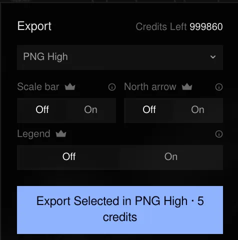
Three toggles under the export format (PNG and SVG) add the apparatus of a printed sheet in a margin band below the map — never on top of the terrain:
- Scale bar — sized from the zone’s real extent, metric.
- North arrow — the map is always north-up.
- Legend — in Lines mode, a line swatch for the contour interval (and the index interval when index contours are on). In Points mode, the smallest and largest glyph with the elevations they stand for.
They are drawn in the stroke colour on an opaque white band, so an export with any of them turned on always has a solid background.
These three are Pro: they’re baked into paid exports only. See Exports & plans.
Last updated 2 October 2026