When your country has no open national model, or your area crosses borders, one of these global models is what you’ll contour. They look alike (most are ~30 m) but differ in the one thing that matters most for contours: do they show the ground, or what stands on it?
At a glance
| Model | Publisher | Type | Grid | Epoch | Heights | Licence |
|---|---|---|---|---|---|---|
| GEDTM30 v1.2 | OpenGeoHub | Terrain (DTM), machine-learning fusion | ~30 m | Composite | EGM2008 | CC BY 4.0 |
| Copernicus GLO-30 | ESA / Airbus | Surface (DSM), radar | ~30 m | 2011–2015 | EGM2008 | Free licence, attribution |
| FABDEM | Univ. of Bristol / Fathom | Terrain (DTM), from GLO-30 | ~30 m | 2011–2015 | EGM2008 | CC BY-NC-SA 4.0 (non-commercial) |
| FathomDEM | Fathom | Terrain (DTM), from GLO-30 | ~30 m | 2011–2015 | Not stated; built on GLO-30 (EGM2008) | CC BY-NC-SA 4.0 for research; commercial licence |
| SRTM / NASADEM | NASA | Surface (radar, partly through canopy) | ~30 m | Feb. 2000 | EGM96 | Public domain |
| ALOS AW3D30 v4.1 | JAXA | Surface (DSM), optical stereo | ~30 m | 2006–2011 | EGM96 | Free incl. commercial, JAXA terms |
| ArcticDEM v4.1 | Polar Geospatial Center | Surface (DSM), satellite stereo | 2 m (also 10, 32 m…) | Multi-year | WGS84 ellipsoid | CC BY 4.0 |
| REMA v2 | Polar Geospatial Center | Surface (DSM), satellite stereo | 2 m (also 10, 32 m…) | Multi-year | WGS84 ellipsoid | CC BY 4.0 |
| ETOPO 2022 | NOAA NCEI | Land + sea floor | 15 arc-sec (~450 m) | Composite | EGM2008 | Public domain |
Surface or terrain: the choice that changes your contours
A surface model (DSM) records the first thing the sensor hits: tree tops, roofs. A terrain model (DTM) tries to remove all that and keep the bare ground. The two terms are used loosely in the wild; the definitions above follow the review by Guth et al. (2021), written by the DEMIX group of DEM researchers. Over a forest, contours from a surface model follow the canopy, which can sit several metres to tens of metres above the ground (radar partly penetrates foliage, so the offset varies); over a town they draw blocks.
For contour lines, you almost always want a DTM. Among the open global ~30 m models, three aim to be one: GEDTM30, FABDEM and its successor FathomDEM. FABDEM and FathomDEM are free only for non-commercial use, which leaves GEDTM30 as the open bare-earth option for client work and products.
What independent studies found. The DEMIX group ranked the global 1 arc-second models against DEMs aggregated from 1–5 m airborne lidar, across a wide set of test sites covering different landforms and land covers:
- Copernicus GLO-30 and FABDEM come out on top, slightly ahead of ALOS AW3D30, and clearly ahead of NASADEM and SRTM (Bielski et al., 2024).
- The bare-earth versions improve the elevation values, but not slope, curvature and stream networks, so they don’t beat Copernicus on the shape of the land. And no global model does well on low, flat terrain: for accurate work there, the authors recommend airborne lidar (Guth et al., 2024).
GEDTM30’s own paper reports that it cuts Copernicus’s error by about 25% in built-up areas and 27% under dense forest. Against GNSS stations it had the lowest error of the global DTMs tested, while FathomDEM did best against reference lidar DTMs (Ho et al., 2025). In other words, the bare-earth models are close, and which one wins depends on the test.
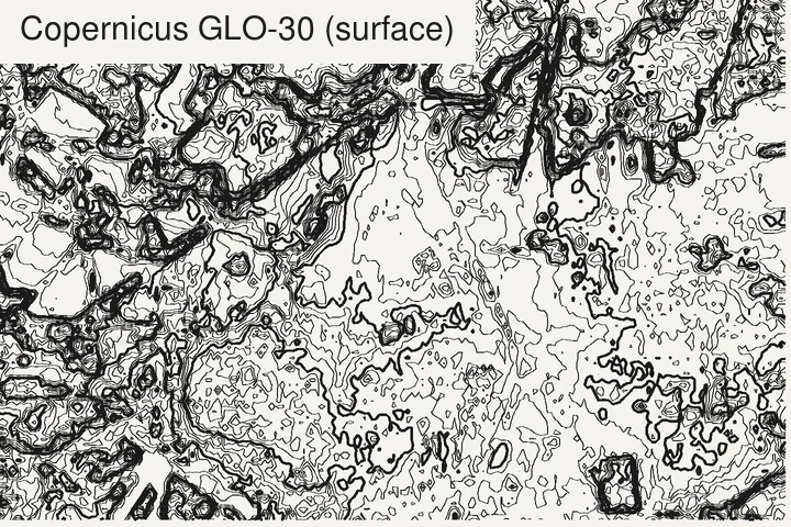
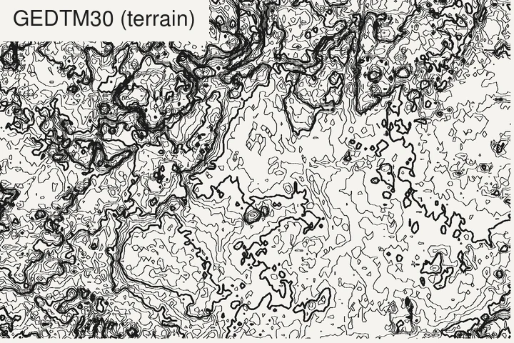
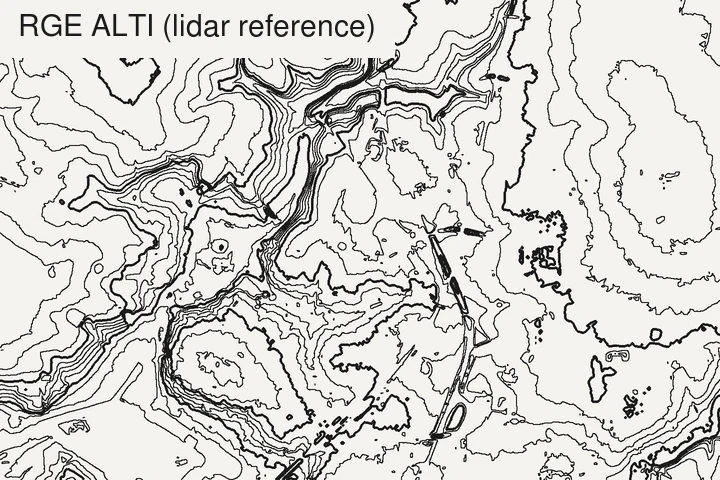
We tested GEDTM30 against Copernicus and national lidar at ten sites, from forests to cities: results and method here.
Notes on each model
GEDTM30. Built by Yu-Feng Ho, Tom Hengl and colleagues at OpenGeoHub. A random forest model, trained on almost 30 billion ICESat-2 and GEDI laser heights, fuses Copernicus GLO-30 and ALOS AW3D30 with canopy and building height layers (Ho et al., 2025). Heights refer to the EGM2008 geoid. Values are stored as integers ×10 (decimetres): divide by 10 if you read the raw file. It ships an uncertainty layer (the spread of the model’s predictions), highest in dense forest and on steep ground, which is worth a look before trusting a small feature. It covers all land except Antarctica.
Copernicus GLO-30. The reference global surface model, from the TanDEM-X radar mission (2011–2015), with water bodies flattened and rivers made to flow consistently. Absolute vertical accuracy is specified at under 4 m (90% linear error). Ideal for hillshades and 3D renders where trees and buildings are welcome; less so for contours in forested or urban areas. The 10 m European version (EEA-10) can only be downloaded by eligible users, such as public authorities, not by the general public.
FABDEM and FathomDEM. Both start from Copernicus GLO-30 and remove forests and buildings with machine learning: FABDEM with random forests trained on reference data from 12 countries (Hawker et al., 2022), FathomDEM with a vision transformer network (Uhe et al., 2025). FABDEM covers 60°S to 80°N. Both are free for research and non-commercial use; commercial use needs a licence from Fathom.
SRTM and NASADEM. The historic reference from a single Space Shuttle mission in February 2000, between 60°N and 56°S (Farr et al., 2007). NASADEM is NASA’s 2020 reprocessing of it, with better heights and fewer voids. Still useful for comparisons and for change over time; the DEMIX ranking recommends it only when you need the topography of the year 2000.
ALOS AW3D30. JAXA’s optical stereo model from the PRISM camera on the ALOS satellite (2006–2011), derived from its 5 m AW3D product (Tadono et al., 2014). Being optical, it has no data under cloud and snow: those gaps are filled from other models, and the quality mask of version 4.1 (April 2024) lists Copernicus GLO-30 and ArcticDEM among the fill sources, so a small part of a tile can come from another source and another date. Free for commercial use under JAXA’s terms, after a free registration.
ArcticDEM and REMA. Superb 2 m detail over the poles: all land north of 60°N for ArcticDEM (Porter et al., 2023), Antarctica for REMA (Howat et al., 2022). Two traps: they are surface models (PGC says plainly there is no bare-earth product), and heights are above the ellipsoid, so coastal values can be negative. Convert to orthometric heights before mixing them with anything else. ArcticDEM over Alaska from June 2022 onward is not public.
ETOPO 2022. The one to use when the sea floor matters: a seamless land-and-bathymetry grid, also published in a version that shows the bedrock under the Greenland and Antarctic ice sheets (MacFerrin et al., 2025). Far too coarse for land contours at local scale.
Which one should I use?
- Contours, commercial use, anywhere but Antarctica: GEDTM30.
- Hillshade, 3D render, game terrain, and trees don’t bother you: Copernicus GLO-30.
- Research or personal project needing bare earth: FABDEM or FathomDEM are also options.
- Arctic or Antarctic: ArcticDEM / REMA, converted from ellipsoid heights.
- Coastline with the sea floor: ETOPO 2022 (or GEBCO), for small-scale maps.
- Flat, low-lying ground, or anything finer than 30 m: look for a national lidar model first: France, United States.
What TopoLines uses
GEDTM30 v1.2 is our default everywhere, read from OpenTopography with OpenGeoHub’s own server as a mirror, and AWS Terrain Tiles as a fallback if both are down. Details and credits in the datasets docs.
References
- Ho, Y.-F., Grohmann, C. H., Lindsay, J., Reuter, H. I., Parente, L., Witjes, M. & Hengl, T. (2025). GEDTM30: global ensemble digital terrain model at 30 m and derived multiscale terrain variables. PeerJ 13, e19673. doi:10.7717/peerj.19673
- Hawker, L., Uhe, P., Paulo, L., Sosa, J., Savage, J., Sampson, C. & Neal, J. (2022). A 30 m global map of elevation with forests and buildings removed. Environmental Research Letters 17(2), 024016. doi:10.1088/1748-9326/ac4d4f
- Uhe, P., Lucas, C., Hawker, L., Brine, M., Wilkinson, H., Cooper, A., Saoulis, A. A., Savage, J. & Sampson, C. (2025). FathomDEM: an improved global terrain map using a hybrid vision transformer model. Environmental Research Letters 20(3), 034002. doi:10.1088/1748-9326/ada972
- Bielski, C., López-Vázquez, C., Grohmann, C. H., Guth, P. L., Hawker, L., Gesch, D., Trevisani, S., Herrera-Cruz, V., Riazanoff, S., Corseaux, A., Reuter, H. I. & Strobl, P. (2024). Novel approach for ranking DEMs: Copernicus DEM improves one arc second open global topography. IEEE Transactions on Geoscience and Remote Sensing 62, 1–22. doi:10.1109/TGRS.2024.3368015
- Guth, P. L., Trevisani, S., Grohmann, C. H., Lindsay, J., Gesch, D., Hawker, L. & Bielski, C. (2024). Ranking of 10 global one-arc-second DEMs reveals limitations in terrain morphology representation. Remote Sensing 16(17), 3273. doi:10.3390/rs16173273
- Guth, P. L., Van Niekerk, A., Grohmann, C. H., Muller, J.-P., Hawker, L., Florinsky, I. V., Gesch, D., Reuter, H. I. et al. (2021). Digital elevation models: terminology and definitions. Remote Sensing 13(18), 3581. doi:10.3390/rs13183581
- Farr, T. G., Rosen, P. A., Caro, E., Crippen, R. et al. (2007). The Shuttle Radar Topography Mission. Reviews of Geophysics 45(2), RG2004. doi:10.1029/2005RG000183
- Tadono, T., Ishida, H., Oda, F., Naito, S., Minakawa, K. & Iwamoto, H. (2014). Precise global DEM generation by ALOS PRISM. ISPRS Annals of the Photogrammetry, Remote Sensing and Spatial Information Sciences II-4, 71–76. doi:10.5194/isprsannals-II-4-71-2014
- Porter, C., Howat, I., Noh, M.-J., Husby, E., Khuvis, S. et al. (2023). ArcticDEM – Mosaics, Version 4.1. Harvard Dataverse. doi:10.7910/DVN/3VDC4W
- Howat, I., Porter, C., Noh, M.-J., Husby, E., Khuvis, S. et al. (2022). The Reference Elevation Model of Antarctica – Mosaics, Version 2. Harvard Dataverse. doi:10.7910/DVN/EBW8UC
- MacFerrin, M., Amante, C., Carignan, K., Love, M. & Lim, E. (2025). The Earth Topography 2022 (ETOPO 2022) global DEM dataset. Earth System Science Data 17, 1835–1849. doi:10.5194/essd-17-1835-2025
Last updated 5 November 2026