
HD exports trace your zone from a national lidar model wherever one covers it: IGN RGE ALTI in France, swissALTI3D in Switzerland, USGS 3DEP in the United States, and others. When none can serve the zone, HD needs a backup. Until this week that backup was AWS Terrain Tiles, labelled “10 m”.
While making comparison images for this site, we noticed that this backup looked worse than the free 30 m model. So we measured it. It was. From version 2.49.1, an HD zone with no lidar is traced from GEDTM30 instead, and the label says so. This post explains what we tested and what changes for you.
When HD has no lidar
A national model can’t serve a zone when:
- the zone is in a country we don’t cover yet;
- it crosses a border (a map is never stitched from two datasets);
- it is larger than the model allows (about 85 km² in France, Spain and the US);
- the national server doesn’t answer in time.
In all four cases the zone used to get the AWS tiles. It now gets GEDTM30.
What we tested
We picked nine zones of about 3 × 3 km, all inside a country with open lidar: four in France and one each in England, Switzerland, Spain, the United States and Austria. Mostly mountains, because that is where elevation errors show most on a contour map. For each zone we downloaded:
- the national lidar model, as the reference (the very model HD uses there);
- GEDTM30, the 30 m bare-earth model behind every free map;
- the AWS Terrain Tiles at zoom 13, the grid labelled 10 m.
All three went through the same code TopoLines runs in production. They were then sampled on one grid of about 10 m, fine enough not to favour the coarser model, and we measured the average error against lidar (RMSE).
We first checked our own work. A bad error can come from a bug, for example tiles placed a few pixels off. So we compared our reprojected AWS tiles with the raw files: they agree to within a few metres. We also slid each model up to 300 m in every direction to look for an offset. No shift brought the AWS tiles close to the lidar. The error is in the data, not in how we read it.
What we found
At eight sites out of nine, GEDTM30 was closer to the lidar ground. Its error was 4 to 13 m; the AWS tiles’ was 9 to 113 m.
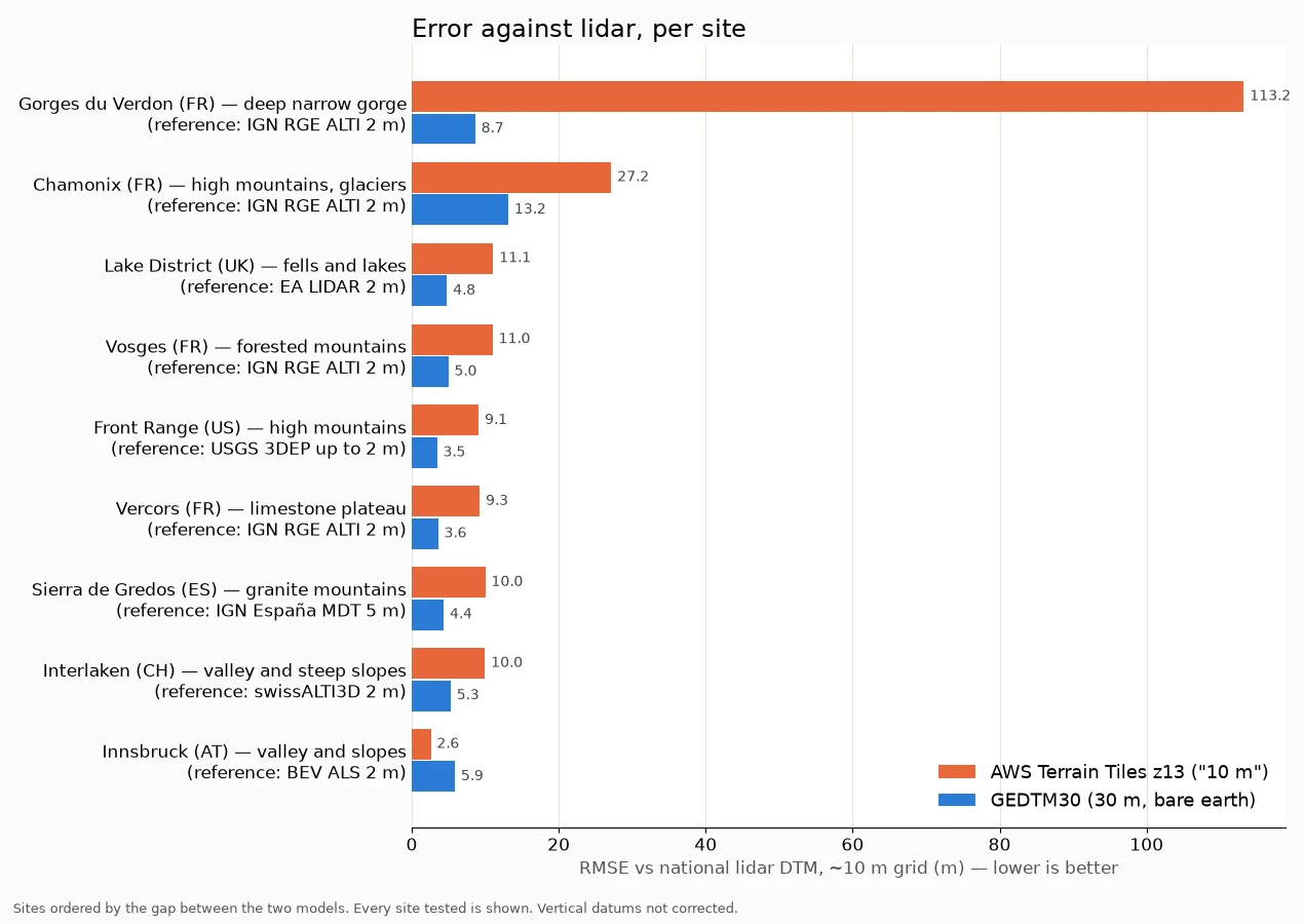
| Site | Reference | AWS Terrain Tiles | GEDTM30 |
|---|---|---|---|
| Gorges du Verdon (FR) | IGN RGE ALTI | 113.2 m | 8.7 m |
| Chamonix (FR) | IGN RGE ALTI | 27.2 m | 13.2 m |
| Vosges (FR) | IGN RGE ALTI | 11.0 m | 5.0 m |
| Vercors (FR) | IGN RGE ALTI | 9.3 m | 3.6 m |
| Lake District (UK) | EA LIDAR | 11.1 m | 4.8 m |
| Interlaken (CH) | swissALTI3D | 10.0 m | 5.3 m |
| Sierra de Gredos (ES) | IGN España MDT | 10.0 m | 4.4 m |
| Front Range (US) | USGS 3DEP | 9.1 m | 3.5 m |
| Innsbruck (AT) | BEV ALS | 2.6 m | 5.9 m |
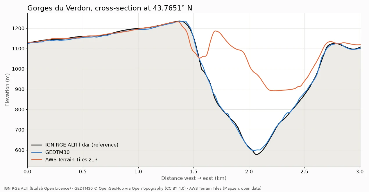
The Gorges du Verdon show the problem best. The gorge is just over a kilometre wide from rim to rim and more than 600 m deep. Across it, GEDTM30 follows the lidar down to the river. The AWS tiles barely see the gorge: at its deepest point they sit about 400 m above the riverbed.
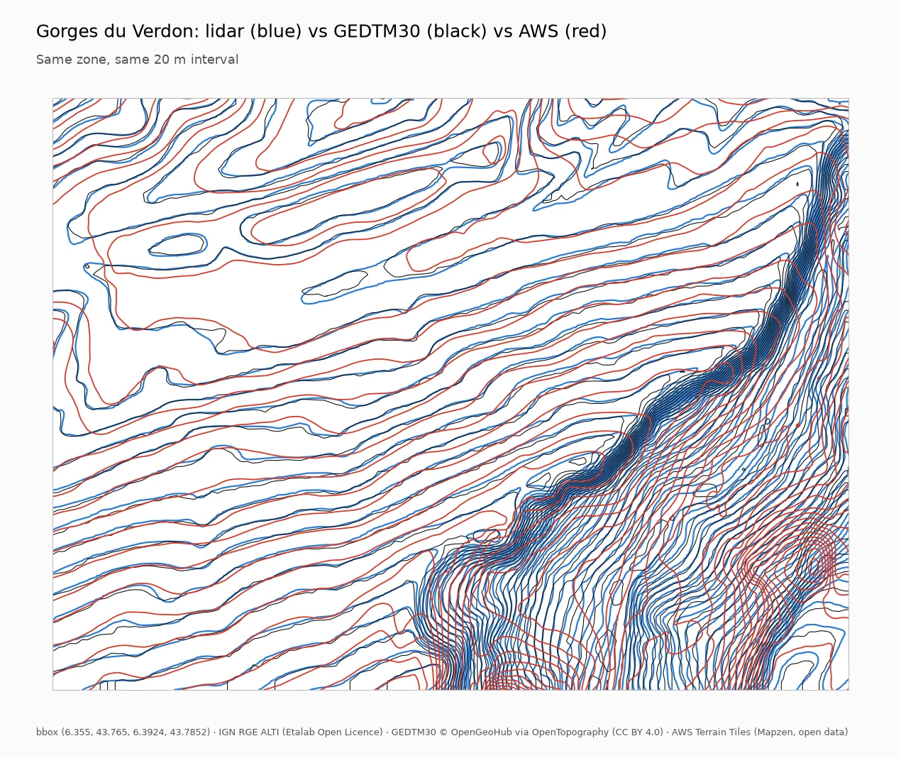
On a map, that means contour lines that cross the gorge where there is a 600 m drop:
Innsbruck is the exception. There, the AWS tiles were closer to the lidar than GEDTM30 was; the next section explains why. HD in Austria uses the national BEV lidar anyway, so this changes nothing for Austrian maps.
Why a 10 m grid can be worse than 30 m
The “10 m” was the spacing of the grid, not the detail of the data in it. AWS Terrain Tiles, built by Mapzen and hosted as AWS open data, are a mosaic of many sources. According to their documentation, at this zoom most land comes from SRTM, a 30 m model of “90 m nominal quality”. A few countries were added with finer national data, Austria at 10 m among them. That is why Innsbruck comes out ahead.
SRTM is also a surface model: it measures the top of forests and buildings. GEDTM30 estimates the bare ground underneath, which is what contour lines should follow. We tested that difference separately in Bare earth or treetops?.
A grid of small cells filled with coarse data only looks precise. We would rather show 30 m and mean it.
What changes for you
- Where national lidar covers your zone, nothing changes: HD traces it at the finest grid the zone allows, as before.
- Where it doesn’t, an HD zone is now traced from GEDTM30 30 m, the same model as Standard. We prefer telling you that over selling a number the data can’t back.
- The AWS tiles remain as a backup if GEDTM30’s servers are down, so a trace never fails. They no longer carry a resolution in their label.
- IGN glitches no longer cost you the lidar. About one request in twelve to IGN’s server stalls, and the next one usually answers in a second or two. TopoLines now retries once before falling back.
TopoLines shows you which data you get
You don’t have to take any of this on trust:
- the Precision menu names the source your zone will get, before you generate;
- Map info shows the one that actually served it, fallbacks included;
- every export records that source and its licence in its metadata.
If a zone falls back, you see it. The full list of models and their limits is in Datasets.
How far this goes
This is a practical check, not a study: nine sites picked by hand, small mountain zones, vertical datums left uncorrected. It was enough to show that the backup was worse than the free model at eight sites out of nine. That was enough to change it.
Thanks to OpenGeoHub for GEDTM30 and to OpenTopography for hosting it, to Mapzen and AWS for keeping the Terrain Tiles open, and to IGN, the Environment Agency, swisstopo, IGN España, the USGS and BEV for open lidar.